 Geographical Information System
(Note 1) The Geographical Information System (GIS) for the Veneto region was set up within the context of the "Third Cartography Plan" as a computer-based information system with the aim of managing and disseminating territorial data, as well as carrying out initiatives to document and represent phenomena throughout the region. Furthermore, the project has set up initiatives to monitor the territory, placing particular importance on new scientific findings and indications that are being developed in Italy (Codice dell'Amministrazione Digitale, or Digital Administration Code) and Europe (the INSPIRE Directive) and on the use of new digital technologies.
The GIS was set up and developed in compliance with the requirements for data and information to be accessible, available and interoperable according to the new channels of communication required by the Sistema Pubblico di Connetivitą (SPC), or Public Connectivity System. This is part of a strategic choice to take into account the innovative process of the Public Administration (PA) and to create a new form of interaction between residents and their PAs that allow residents to navigate, consult and download maps, databanks, aerial photographs, images and documents via the Regional WebGIS system.
 Regional Technical Map and the "Geodetic Systems"
Regional Law LR 28/1976 entitled "Formazione della Carta Tecnica Regional (CTR)", or Regional Technical Maps, has reached its aims: the Regional Technical Map covers the entire region with scales of 1:5000 and 1:10000. Regione Veneto continues to update the maps and restructure the territorial databases based on the robust and functional geographical databases available. This process, based on the agreement between the State, Regions and Local Agencies to create geographical databases of general interest (called IntesaGIS), has led to the redefinition of the information system and a restructuring and conversion of the vector data provided by the numerical CTR into a shared geographical database.
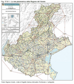
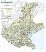
Over the years, mapping activities have led to the creation of the "Regional Geodetic Network", which is part of the national network of the Istituto Geografico Italiano (IGM), or Italian Geographical Institute. More precisely, the Rete regionale planimetrica (Regional Planimetry Network) made up of about 1,550 Vertici Trigonometrici Regionali (VTR) (Regional Triangulated Networks) and Rete altimetrica (Altimetry Network) made up of more than 5,500 Levelling Benchmarks (Caposaldi di Livellazione, or CSL)
(Note 2), have provided the necessary reports regarding the geodetic areas in the region. This archive provides information on the geodetic areas in the region and is a constant point of reference for those involved in measuring and gathering data on geo-topographical phenomena in Veneto
(Figure 17.6.1) and
(Figure 17.6.2).
 Initiatives of Regione Veneto to standardise the geodetic systems
By now it is widely recognised that the information regarding the territory in the region is a fundamental tool for planning initiatives and managing the area. For several years now, various initiatives have been carried out on a national and European level with the aim of establishing "shared languages" that can define new scientific and cultural ideas and issues in order to promote a process of innovation and standardisation of territorial data/information. This process has led not only to new scientific indications, but also to standardised directives.
The complexity of this new scenario, brought on by national initiatives (IntesaGIS and the Digital Administration Code)
(Note 3) as well as by European ones (the INSPIRE Directive)
(Note 4), not to mention new technological applications, has led to several significant operations for revising geodetic parameters. These new operations require systematic and integrated management of information which no longer simply makes reference to the national Gauss-Boaga system, but rather to the articulated system based on indications that provide for a degree of standardisation among the Member States of the European Union.
The development of the Geographical Information Systems involved innovating the procedures for creating
topographic maps to increase data integration and implement the most recent technical and technological solutions for georeferencing territorial data.
Starting with its "Third Cartography Plan", Regione Veneto had already recognised the importance of implementing territorial databanks in order to build an Integrated Spatial Database, i.e. a central repository of data able to support the requirements of the Geographical Information System. With this in mind, Regione Veneto set up a project to develop a Infrastruttura Dati Territoriali (IDT-RV) (Geographical Data Infrastructure), which would be a centralised geographical database for all of the territorial data throughout the region. IDT-RV was developed in compliance with the norms indicated in the Digital Administration Code and the INSPIRE Directive; there is a single shared platform that guarantees interoperability and accessibility to all territorial data and it is based on a network logic. So that it can be used to its full potential, regarding both consultation and data dissemination, the flows and processes for updating data have been made uniform
(Note 5).
In order to integrate the various technical and scientific aspects and to experiment with solutions that are shared both with the national cartography agencies, as well as local agencies in Veneto, the regional government has developed a series of projects related to the monitoring system for the geodetic network, triangulation vertices and datum points. These infrastructures of geodetic data guarantee documentation regarding the geometric and morphological aspects of the territory. They also make it possible to share the datum of maps between different systems and to convert the georeferencing of data from the current Gauss-Boaga system to the WGS84 (World Geodetic System 1984), and even to the more recent National Dynamic Network (Rete Dinamica Nazionale, or RDN). In Italy, implementing this last network involved adopting the ETRF2000 (European Terrestrial Reference Frame) using procedures agreed on together with the Military Geographic Institute.
 The planimetry system
Before discussing the monitoring procedures for the regional planimetry network, it is important to point out that the Regional Technical Map is based on the Gauss system and uses the coordinates of the National Gauss-Boaga System, which for the Western time-zone are from 6° to 12° East of Greenwich and for the Eastern time zone from 12° to 18° West of Greenwich, as indicated by Italy's National Geodetic Commission in the "Norme proposte per la formazione di Carte Tecniche alle scale 1:5000 e 1:10000" ("Norms proposed for the creation of Technical Maps on a 1:5000 and 1:10000 scale") published by the Military Geographic Institute in 1973.
The Gauss projection calls for maps to be created with reference to two different time-zones, which causes significant complications for the information system since the maps do not show the territorial continuity between the two time-zones.
Therefore, in collaboration with the University of Padova, Regione Veneto developed a "Research program to study geodetic network monitoring, mapping, the conversion of geographic coordinates and the network of fixed GPS stations", including activities for analysing geodetic information resources. The ultimate aim of the project is to establish methods for testing the mapping system and to provide indications as to how to develop a program for converting geographic and cartographic coordinates
(Note 6).
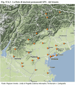
Furthermore, in order to facilitate the conversion of the coordinates used in the various information systems throughout the region, in collaboration with the Military Geographic Institute, the project aims to further develop the "ConVe" software, which is a specific system of uniform and shared algorithms. With regards to the Veneto, the "ConVe" software uses difference matrices, "evenly spaced grids", developed by the Institute to convert mapping coordinates used in different mapping systems (Roma40, ED50, WGS84-ETRF89) and provides specific functions to help manage data in the region's Geographical Information System
(Figure 17.6.3).
 Altimetry system
The altimetry system, which was developed as maps were being drawn, also includes an important integration process that involved establishing high-precision levelling lines drawn in collaboration with the Military Geographic Institute, the National Research Council - Institute of Marine Sciences (ISMAR) in Venezia, the Department of Geophysics at the University of Padova and the Department of Maths and Computer Science at the University of Trieste. This collaboration has resulted in 1,185 km of high-precision levelling lines that have been tested and certified by the Military Geographic Institute and are part of the national altimetry system
(Table 17.6.1).
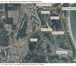
In order to make the various aspects of the "Veneto Altimetry System" uniform, in collaboration with the Faculty of Engineering at the University of Padova, a project was set up to test the altimetry system and develop initiatives aimed at integrating the existing altimetry system and the establishing the procedures to be followed to define the characteristics of the altimetry data needed to carry out the strategies for land monitoring and defence and to study and monitor land lowering (subsidence)
(Figure 17.6.4).
 New scientific indications
Since January 2009, the Military Geographic Institute has worked on developing the national network of GPS stations called Rete Dinamica Nazionale (RDN) (National Dynamic Network), which is a network of 99 fixed stations uniformly distributed throughout the entire country. Four of these stations are part of the Veneto GPS network and they transmit data to one of the Military Geographic Institute's computing centres. The RDN is part of the European Terrestrial Reference Frame (ETRF 2000), which is the system that has most recently been made official in Europe. This new system will allow the Institute to comply with the new reference frame for geodetic data and be continuously aligned with developments in Europe as part of the European Reference Frame (EIREF) project. The implementation of the RDN involved adopting the ETRF2000 system throughout the country; the scientific and normative contents are currently in the process of being approved in compliance with the Digital Administration Code.
Furthermore, in addition to the Universal Transverse Mercator (UTM) and the WGS84 system, the "Italian Time Zone", developed by the Military Geographic Institute, is also used as a reference point. This new system (the so-called "Single Time Zone"), makes it possible to obtain projections from all over the national territory using one single plan without the continuity solutions caused by the two time-zones, East and West.
Although this new scenario promises to provide important scientific solutions, it has required and continues to require systematic analysis and evaluation in order to guarantee the correct alignment of all of the territorial databanks in the region's Geographical Information System.
The creation of the "System of Infrastructures for Geodetic Data" has proven to be effective response in line with Regione Veneto's programming policies, which call for the use of new electronic channels for communication and information exchange. These strategies promote the creation of a patrimony of territorial data and information organised and managed within the context of the region's Geographical Information System in an innovative technical-scientific framework that was designed and developed to exploit the new opportunities for communication and sharing knowledge offered by information technologies.


