-
Statistical department’s site
Home page
Our publications
Chapter 17
31 October - 2 November 2010: the All Saints flood (Note 1)
In his "Naturalis Historia" (Note 2) Gaius Plinius Secundus, better known as Pliny the Elder, described the situation of the rivers in the lagoon area and in the Veneto countryside, providing historical accounts of exceptional events. Although the biggest upsets occurred during the last glaciation with the melting of the ice, in the 1st Century BC the rivers Adige and Bacchiglione mingled with the Po and together they reached the river mouth (Note 3), which shows that the rivers in Veneto also changed their course in more recent periods. Accounts also exist of floods occurring between Late Antiquity and the Early Middle Ages, during which time climate conditions gradually worsened. There is one particular catastrophic event recorded on 17 October 589 known as the "Breach at Cucca", about which Paul the Deacon in his "Historia Langobardorum" wrote "Eo tempore fuit aquae diluvium in finibus Venetiarum et Liguriae seu ceteris regionibus Italiae, quale post Noe tempore creditur non fuisse." (Note 4). A combination of these events, plus the carelessness shown towards maintaining the river network during the Later Roman Empire and the Early Modern Period, led to the flooded rivers abandoning their old riverbeds for lower-lying areas. The Lombards actually used the Adige's old flood plains and the swamp areas which were left behind as borders and natural defences against the Exarchate of Ravenna.
From more recent times we have the flood of 1882, which raised awareness of the need to manage the land better, the breach of the River Po in Polesine in November 1951, and the flood in November 1966.
Non-exceptional events, on the other hand, have been kept well under control for centuries by hydraulic engineering. From the period of the Roman Empire and passing through the Serenissima Republic of Venice, great areas of swampland were turned over for use by the population. The weak points of this process, which has left us with the land that we live on today, are excessive deforestation and the difficulty channelling into the sea certain rivers which were redirected out of the lagoon during the times of the Serenissima in order to avoid it being buried under detritus.
As in all flood plains, the main hydrogeological and environmental risks for the Padano-Veneta plain are floods caused by waters overflowing from the riverbeds when the rivers are full and by events such as landslides and matter being washed down-river. These events are cyclical and are defined by hydraulic and statistical measurements for flow and precipitation, linked to recurrence time and degree of rarity. The inevitableness of these events in Veneto should always be remembered so that the impact on the population and the economy can be kept to a minimum. These natural events, along with earthquakes, seaquakes and volcanic eruptions, continue to cause crises amongst the human population in every corner of the world, and the only way we can beat them is to know them and not to forget their potential with regards the areas threatened by them. One of the reasons we manage to get caught unprepared is linked to human memory and the degree of rarity of these events. In Veneto freak flooding occurs with cross-generational frequency, causing feelings of fear and impotence within the population which go beyond the usual desperation of people who have lost loved ones and property, leading to socio-psychological problems.
The morphology of Veneto is one of the most complex in Italy due to the presence of different physical features. Overall, more than 56% of the region is made up of plains, 29% mountains and almost 15% hills. More than three quarters of Veneto's 4.9 million plus inhabitants live on the plains, whereas, of the remaining quarter, 16.5% live in the hills and 7.1% in the mountains.
The plain is split into two quite distinct areas, the Alta Pianura (Upper Plain) and Bassa Pianura (Lower Plain), which are separated by a line of springs. The Alta Pianura is mainly made up of highly-permeable gravelly materials in the form of large pebbly conoids, created over time by the continual meandering of the water flows; the Bassa Pianura on the other hand is made up of finer sediment-sand and clay-that decreases in size from the mountains down towards the valley. (Table 17.2.1)
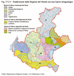
Veneto also contains large coastal lagoons, more than 150 km of beaches and the eastern bank of Lago di Garda, the biggest lake in Italy. It also has a wealth of water, both underground and surface, whose hydrographic network is made up of six catchment areas of national importance: Adige, Brenta-Bacchiglione, Livenza, Piave, Po and Tagliamento; two of interregional importance: Fissero-Tartaro-Canalbianco and Lemene; and three of regional importance: the draining basin in the Laguna di Venezia, the plain between Livenza and Piave, and Sile. (Figure 17.2.1)
We will now try to provide a picture of what happened during the All Saints flood. An Atlantic storm led to a wide and persistent cyclonic circulation between the Ligurian Sea and the Tyrrhenian Sea which pushed itself along to the African coast, conveying an intense and persistent flow of warm-humid Sirocco currents on Veneto. These events caused precipitation over the whole of the region with extreme quantities falling on the pre-Alpine and foothill areas. Persistent rain, sometimes turning into downpours, fell on Veneto from Sunday 31 October to Tuesday 2 November, in particular in the pre-Alpine and foothill areas, where over 300 mm fell overall; certain areas received more than 500 mm (Note 5). The event was also characterised by persistent Sirocco winds, both on the coast and at altitude, leading to a significant raising of the snow line. For most of the duration of the event, the snow line was above 2000 m leading to the melting of the pre-existing snow, especially in the western pre-Alpine areas. All of this led to serious hydraulic pressure and to geological instability throughout the region. The results from sea water samples taken by the monitoring network of Veneto's Regional Agency for Environmental Prevention and Protection (ARPAV) show that the Upper Adriatic had a lower salt and oxygen content and was muddier in the months following the event because of the exceptional influx of water and matter caused by the overflowing rivers in November.
Analysis of the data on areas of high hydrogeological and hydraulic risk, defined for the first time in December 2006 (Note 6), shows that the average daily rainfall was particularly high in the foothill and mountain areas especially, reaching 149.5 mm on 1 November in the Upper Brenta-Bacchiglione basin. Maximum values were extremely high in the mountain and foothill areas, in the Lower Piave and Sile basins, and in the Laguna di Venezia drainage basin with peak figures reaching 255.6 mm on 31 October in the Upper Piave basin, in the Valpore station in Seren del Grappa.
Looking at the event as a whole, it can be seen that some extremely high maximum local figures were recorded: higher than 500 mm in the Upper Piave and Upper Brenta-Bacchiglione basins; higher than 300 mm in the two high-risk areas, which include the areas of the Adige, Garda, Monti Lessini, the Lower Piave and Sile basins, and the Laguna di Venezia drainage basin; and higher than 200 mm in the area of the Lower Brenta-Bacchiglione. The average areal values of rainfall in various areas were also very significant, demonstrating that particularly heavy rainfalls hit vast areas and not just limited local areas. The average areal values for the event overall were 339 mm in the Upper Vicenza area, around 175 mm in the mountain and hill areas of Belluno and Verona, and 128 mm in the area which includes the Lower Piave and Sile basins and the Laguna di Venezia drainage basin. (Figure 17.3.1) and (Table 17.3.1)
After the disturbance over the main part of the southern Dolomites, the pre-Alpine and the foothill area, more than 200 mm overall were measured, with a vast swathe of the pre-Alpine and foothill areas recording between 300 and 400 mm and local peaks of over 500 mm, with an absolute maximum figure of 587 mm in the province of Belluno in Valpore - Seren del Grappa. The northern Dolomites recorded values from 75 to 200 mm, with figures increasing from North towards South. On the plain, values ranged from 200 mm in the more northern areas near the foothills to under 10 mm in Rovigo, with figures decreasing from the North West towards the South East. (Figure 17.3.2)
In order to obtain statistics on the degree of rarity of an event, the concept of recurrence time is used; this is the interval of time within which a certain amount of precipitation is equalled or exceeded once on average. The amount of rainfall in a certain time interval is analysed by making reference to the maximum annual rainfall per station within the same timespan for the entire duration of activity. In order to correctly evaluate the recurrence times of intense rainfall, a sufficiently numerous sample of data is required. For the case in question, most of the stations examined only have 18-19 years of observation behind them. For this reason, an accurate evaluation of recurrence times of over 20 years would not be possible, therefore the decision was made to limit it to a generic indication of "recurrence time of over 50 years". It can be seen that in many cases the stations give recurrence intervals of around 50 years or more, which indicates the extreme severity of the phenomenon.
(Table 17.3.2)
To this regard a comparison with some historical data on rainfall may be useful. An initial comparison places this flood among the two or three largest and most serious events that have struck the pre-Alpine and foothill areas of Veneto in the last 50 years. These areas are the rainiest areas in the region on average, especially in the autumn.
In the central-western, pre-Alpine and foothill areas of Vicenza and Verona in particular, the maximum values recorded during 24 and 48 hours in some cases exceeded the record figures registered, in most cases, during the events of October 1992 and November 1966. In Castana for example, in the municipality of Arsiero (province of Vicenza) in the Posina basin, 431 mm were recorded in 2 days compared to the previous highest values of 326 mm recorded on 4 and 5 November 1966 at the station in Posina and 313 mm recorded on 4 and 5 October 1992 at the station in Castana itself. In Turcati in the municipality of Recoaro (province of Vicenza) in the Agno basin and in San Bortolo (province of Verona) on the eastern Lessini mountains, the values recorded over 24 and 48 hours are very similar to the record figures dating from the events of 4 and 5 October 1992.
Record figures were also easily exceeded in the eastern foothills, in the north of the province of Treviso. In Follina for example 313 mm fell in two days compared to a previous record of 280 mm, registered in October 1928 in the nearby historic station of Cison di Valmarino. This station recorded 178 mm during the historic flood of 4 and 5 November 1966.
In the eastern pre-Alpine area, in the province of Belluno, the maximum values recorded in two days in Valpore, municipality of Seren del Grappa, and in Cansiglio were 463 mm and 432 mm respectively, lower only than the measurements taken during the November 1966 flood.
An analysis showing the differences between the event in question and the events from 1992 and 1966 provides a good summary of the situation. In both of the figures, a higher concentration of rainfall in the pre-Alpine and foothill areas compared to the two events in the past is plain to see. Compared to the 1966 disaster, the 2010 flood was certainly more moderate on the plain, in the Alpine areas of north Belluno, Trentino and the northern areas of Friuli, but was more severe in the pre-Alpine and foothill areas, i.e. northern Verona, Vicenza and Treviso and the lower Belluno area. (Figure 17.3.3) and (Figure 17.3.4)
With regards hydrometric levels, the available data are subject to some uncertainty. Although they mainly refer to readings made by the stations of the Veneto region network in real time, these data also take measurements from the stations of the networks of the Autonomous Province of Trento and of the Friuli Venezia Giulia region. Other data were also supplied during the event by the licensees of the primary storage operations for the lining of the main waterways. In certain cases, due to extreme situations, such as breaches of riverbanks, floods, and overflowing due to constructions and confluences, these data should be approached carefully, bearing in mind that some stations stopped working just before the water peaks because their instruments could not deal with the figures being recorded.
In any case, whilst data from the stations is being verified and compared with the manual readings of the plemyrameters from past events used by the Padova Civil Engineering Project Unit, we believe it would be useful to provide some graphs on the flood waves compared to the maximum registered high-water levels.
The waters were particularly high in the basin of the rivers Agno-Guà and Fratta-Gorzone. Water levels reached by the River Agno in Recoaro just brushed record levels, whereas levels in Ponte Brogliano ever so slightly exceeded previous records. In Borgofrassine on the other hand levels had exceeded the past record even before the breach of the Frassine, which happened at around 2:30 pm; this went on to have a major effect on the water levels down-river from the breach itself. The levels of the Fratta-Gorzone system were also influenced by the breaches of the Frassine as the outflows from the latter merged in various ways with the Fratta-Gorzone system at different times. (Figure 17.3.5)
The high water in the River Bacchiglione caused several problems during the event, so much so that all of the sections exceeded past maximum levels. The plemyrameter in Montegalda stopped working, presumably because of the high-water peak. While the flow was being measured, slightly upstream of the bridge where the sensor is located, the right-hand side of the riverbank began to overflow, with a considerable amount of water leaving the river channel. (Figure 17.3.6)
The tributaries of the Bacchiglione also recorded water levels which were higher than or very close to the record levels. The Tesina in Bolzano Vicentino exceeded the previous maximum high-water level, and the Posina in Stancari, Vicenza, equalled its previous maximum high. (Figure 17.3.7)
In order to estimate the freak nature of the water levels reached by the Bacchiglione in November 2010, it is useful to compare them with the historical records of the Padova Civil Engineering Project Unit. For the levels measured in Bovolenta and Pontelongo, the only historical event they can be compared with is from 1966 when the overflow and regulator constructions had already been completed in Voltabarozzo. The high-water records from previous times occurred under very different structural circumstances. We should also bear in mind that, unlike the events of 1966, there were actually two breaches in 2010: one in Tesina Padovano and one in Ponte S. Nicolò. (Table 17.3.3)
Figure 17.3.1
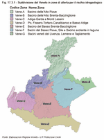
Table 17.3.1

Figure 17.3.2
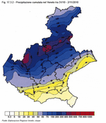
Table 17.3.2
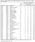
Figure 17.3.3
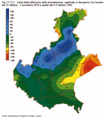
Figure 17.3.4
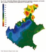
Figure 17.3.5
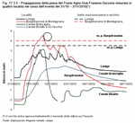
Figure 17.3.6
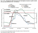
Figure 17.3.7
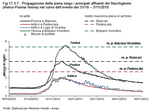
Table 17.3.3

Impact
The impact on the population was very serious: two dead, one missing, many injured and thousands evacuated. Besides the physical damage, the psychological effects on the people affected also need to be taken into account. To this regard a group of volunteer psychologists got involved to help flood victims overcome the emergency situation. Since it is not possible, at the time of writing, to provide a full report of the costs of what happened, the following figures intend to illustrate the impact on the region and on its economy.
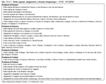
A simple list per province of breaches of riverbanks, flooding and instability caused by the event enables us to understand the enormity of what happened and the difficulty faced by the population and by the aid givers in trying to deal with the emergency. Included in the operations were Regione Veneto, the national and local Civil Protection, Municipalities, Provinces, Prefectures, Local Health Services, Reclamation Authorities and Basin Authorities. Friuli Venezia Giulia, Valle d'Aosta, Marche, Emilia Romagna, Piemonte and Lombardia also gave their support. Along with these organisations, help was also lent by around 3,000 Civil Protection volunteers, around 800 fire-fighters, of whom one hundred or so came from other regions, around 300 soldiers, and all of the available police force. (Table 17.4.1)
Provisional and partial data from 2 May 2011 show that the largest amount of movable and immovable property was damaged in Vicenza; this was due to the flooding in the historical centre of Vicenza in a very busy residential area which contains a high density of commercial outlets. Thousands of houses and buildings were also damaged in the provinces of Padova and Verona, several hundred in Treviso and dozens between Belluno, Rovigo and Venezia.
The Veterinary Services of the Health Authorities involved reported a total of over 151,000 animals requiring compensation killed by the event, all of them in the municipalities of the province of Padova. Around 112,000 chickens, 36,000 turkeys and 3,000 rabbits came from intensive livestock farms, while another 59 of the deaths were of bigger animals, such as cows, pigs and goats, almost all of which were also from farms. We should also add wild animals to the numbers of dead animals counted by the Veterinary Services of the Health Authorities.
Particular attention should also be paid to all the production and trade activities which were brought to their knees by what happened. Here, besides the direct, material damage we should also take into account the consequences on competitiveness and on the determination to start all over again.
Waste is also another question to be taken into consideration: apart from the need to dispose of enormous quantities of non-separated waste, the flood also caused polluting agents from purification plants, hydrocarbon tanks, deposits of solvents, paints etc. to disperse across the region and they required some immediate damage-control operations. Nevertheless, samples and analyses carried out by ARPAV at the end of March 2011 in the provinces of Padova, Verona and Vicenza show limited levels of soil pollution. In practically every case, the analyses came back as completely environmentally compatible, with values within the legal limits and falling within the natural background level with regards metals and heavy hydrocarbons present in the ground and sediment. Two samples contained values that were very different from the standard. One in the province of Padova with anomalous amounts of chrome, and one in the province of Verona with excessive levels of copper, which, however, may derive from pesticide treatments congruous with farming practices.
Intervention
During the disaster and the days directly afterwards, 129 works got underway and practically all of them have now been finished. Of these initial work sites, 111 were set up by the Civil Engineering Project Unit and 18 by the Reclamation Authorities, for a total cost of around 40 million euro. They were what are known as emergency works to prop up collapsed riverbanks, stop landslides and restore basic functionality once more after an event which flooded 140 km2 of land, some of which stayed flooded for more than a week. Other interventions were planned at the same time to back up the initial ones or to help restore water safety to pre-flood levels or to improve them. Afterwards other emergency interventions were carried out to deal with two further floods: the first one on Christmas Eve 2010, the second on 16 March 2011, which, among other things, flooded part of the populated centre of Soave. Overall, the 249 works were connected to the flood, more than 100 of them have already been completed, another 100 are still being carried out and the remainder are in the final stages of being planned, authorised or contracted out. Almost two thirds of the municipalities which claimed damages have already received an initial part-payment on the reimbursement for the damages reported. Amounts were distributed to 5 provincial and 228 municipal governments (Note 7) based on the "Quantification of Damage" forms sent out by the authorities and handed in to the Executive Commissioner by 12 January 2011. Regione Veneto distributed a total amount of over 118 million euro to the Municipalities and Provinces devastated by the floods.
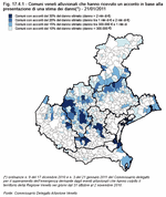
In order to create a list of the Municipalities affected, the total amount of damage reported was taken into account and four classes were created in order to decide on each amount. Twenty-eight Municipalities received an initial sum of 30% of the total damages claimed, equalling more than two million euro; twelve of the municipalities are in the provinces of Vicenza and Padova. Twenty-seven
municipalities have received a sum equalling 20% of estimated damages, adding up to between one and two million euro, and fifty-eight municipal governments with damage estimates of between 300,000 and one million euro have received 5% of the costs. The remaining 115 municipalities received 10% of the sum of the damages declared. (Figure 17.4.1)
Response times were very, very tight. On 2 November the regional government declared it a crisis and on 5 November the national government declared a state of emergency. On 13 November an order issued by Prime Minister Silvio Berlusconi named a Commissioner to oversee the emergency and the appropriation of 300 million euro was announced. On 15 December, around one month later, the 300 million euro indicated in the Prime Minister's order were actually made available for the Commissioner in a bank account created to this end with Banca d'Italia. On 17 December the first contributions, to the tune of 93.35 million euro, reached the 26 worst-hit municipalities, covering 30% of the reported damage. On 20 December, 11 million euro towards damages had arrived in the coffers of the other municipalities. A further 50 million euro were set aside to pay for a part of the emergency works which had already been carried out and for the other urgent interventions, which in the meantime have all been planned and are ready to get started. After the further flooding on 16 March this year, new works were added to the list, for a total of around 30 million euro.
In the meantime a Strategic Intervention Plan for risk mitigation has been prepared for a total amount of around 2.7 billion euro. This plan will be proposed through an order by the Commissioner. After that, initiatives to carry out the measures required by the next planning phases and to gather the necessary funds can be set up.
Solidarity
By Friday 29 April 2011, a sum of 5,048,826 euro had been raised for the flood victims, 1,815,408 of which came from people donating through text messages to show their solidarity. Half of the donations were from bank transfers, almost 40% of which went into the Conto Corrente Solidarietà, an account set up especially for this purpose, and almost 10% into the Conto Tesoreria, a cash account, both set up by Regione Veneto. Text messages worth two euro each accounted for 36% of the total collected. Around 15% has already been allocated to getting the Pusterla bridge back into working order, with financial aid also coming from the Municipality of Vicenza. (Table 17.4.2)On 29 April 2011, just over 2 million euro had been deposited in the Conto Corrente Solidarietà. The business sector favoured this method as a way of generously demonstrating its solidarity, donating around 875,000 euro. Many individual citizens also contributed to it, providing around half a million euro, and public bodies sent in just under that amount. The remaining amount, just under 10%, was collected through fund raisers organised by groups of citizens, mainly belonging to associations but also to schools, public bodies, political parties, volunteers, municipalities and also two prisons.
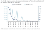
An analysis of the number of bank transfers going into the Conto Corrente Solidarietà week by week shows a decreasing trend over time, with an exception during the period leading up to Christmas. The amount sent in per week followed an initial growth curve, which indicates that the most generous donations, in absolute terms, which came from the business sector, took a couple of weeks to be quantified for technical reasons. For similar reasons, the subsequent downward trend was interrupted during the Christmas week by some peaks in donations. (Table 17.4.3) and (Figure 17.4.2)
Apart from money, goods were also donated to help those directly involved deal with the initial impact of the emergency and to enable small clearance and clean-up operations to take place. These goods included electrical appliances, furniture and tools, toiletries and also heaters. (Table 17.4.4)
Of the sum collected, 750,000 euro have been allocated to structural repair work on the Pusterla bridge in Vicenza to get it back into working order. The order determining the financing of this repair work on a public site destroyed by the River Bacchiglione also states that the remainder of the overall costs, 2.2 million euro, should be covered by the municipal government of Vicenza. Other solidarity funds, as requested by the Commissioner overseeing the emergency, will also be allocated to "repairing exemplary works of a public nature or of collective use which are of importance to the citizens and to the safety of the region." The restoration of structures of this type will stand as witness over time to the generosity of the hundreds of people, institutions and societies which lent a hand to the people of Veneto in order to bring the region back to normality following the disaster.


