(Note 1) The Inventario dei Fenomeni Franosi in Italia (IFFI), or Italian Landslide Inventory, promoted in 1997 by the Committee of Ministers for Land Defence (ex-Law 183/89), was born out of the need to provide as complete a picture as possible of the state of geological instability in Italy in order to better understand its problem of "hydrological instability". Italy's regions and autonomous provinces were assigned the task of implementing the project in compliance with a series of specific conventions made with the National Geological Service.
Participation in the IFFI project in the Veneto region offered the opportunity to create a single databank of cases of hydrogeological instability throughout the region in response to a clear need, in both public and private spheres, to have a point of reference for managing and planning activities in the region.
Most of the data in Veneto's regional IFFI database come from reports of landslides, the paper and computer-based archives of various public agencies, and publications (such as scientific studies and the National Project for Geological Mapping - CARG). The delimitations of the most significant landslides are redefined by analysing aerial photographs taken over time in order to, among other uses, evaluate the state of landslide activity. Furthermore, in some cases, data have been integrated with specific field observations, which also make it possible to update the iconographic archive
(Note 2).
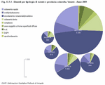
Currently, a total of 9,500 landslides have been registered in Veneto by the IFFI Project, covering a total area greater than 220 km2. The province with the most hydrogeological instability is Belluno, with a total of 6,000 landslides. These phenomena tend to be concentrated in the Alpago area and in the upper part of the Cordevole and Piave basins for the province of Belluno, the Euganei Hills for the province of Padova, the valleys of the rivers Agno and Chiampo for the province of Vicenza and the Val d'Illasi in the province of Verona
(Figure 17.5.1).
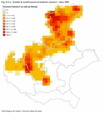
The various types of hydrogeological instability are distributed in an uneven manner throughout the region. This is due both to the current data available, as well as to the particular lithology of the substrata. Falls are the main type of hydrogeological instability and tend to happen where there are significant calcareous formations, such as those near Asiago, along the valle del Brenta (Vicenza) and on the western side of Monte Baldo, to the east of Lago di Garda (Verona). These falls mostly involve the levels of chalk (composed of mineral calcite) in the Raibl Formation and the Bellerophon Formation, which have also been found in the Agordino area (Belluno). The areas that are subject to widespread falls tend to be those where detrital deposits have developed locally due to porous sedimentary rock that has disintegrated rapidly. The falls that have been reported only regard those that involve inhabited areas where the landslides are reported in archives, whereas to date forms of disintegration that take place in the calcareous high plains (Asiago, Cansiglio, Vette Feltrine) have still not been taken into consideration
(Figure 17.5.2).
As far as the impact of landslides on human activity is concerned, roads appear to be the most affected (2,601 damage reports), followed by agricultural activity (1,597) and residential areas (1,300 landslides). The information gathered for 4,710 landslides is not sufficient to identify the type of damage caused.
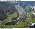
The region has a total land surface of more than 18,000 km2, and the areas affected by landslides cover 222.54 km2. The proportion of mountainous-hilly areas in the region affected by landslides is 3%. This percentage was defined using the Landslide Risk Index and provides information on how extensive landslides are compared to the overall mountainous-hilly area in the region
(Figure 17.5.3).
@2 Uses of the Regional IFFI Landslide Databank and its updates
The implementation of the IFFI project in the region has led to the creation of a Regional Landslide Databank that, with the enormous amount of data that has been collected, has become an information tool that can be used for many different purposes. Some of these include evaluating the danger of landslides, territorial planning, infrastructural planning, and land defence planning. Given the importance of these uses, it is equally important to periodically update the databank so that it remains an effective tool over time.
The Regional IFFI Landslide Databank serves as point of reference regarding hydrogeological instability. In addition to being used for specific projects, it is used for all of the territorial planning activities: PAI, PAT, PATI, PTCP, PTRC
(Note 3) and for the Emergency Plans of the Civil Protection Department.
In addition to territorial planning, the database is also useful, if not fundamental, for professionals in the sector and scientific organisations that need to have an overall picture as a basis for carrying out specific studies.
In the region, the data is mainly used to define geological risk when drawing up and revising the Piani di Assetto Idrogeologico (PAI), or Hydrogeological Structure Plans, and forecasting and monitoring land effects within the context of the Centro Funzionale Decentrato, or Local Operations Centre
(Note 4). The Local Operations Centre, established in April 2009, includes both the Civil Protection Department and environmental agency ARPAV. Among the initiatives within this area, Regione Veneto is involved in a process of interpreting and using the various types of data revealed by the Bollettini di Criticità Idrogeologica (Critical Hydrogeological Reports) in order to contribute to the process of forecasting and managing critical hydrogeological situations throughout the region.
Another initiative that the Local Operations Centre, together with operational support from ARPAV, has set up in order to define possible hydrogeological hazards is the monitoring of several major landslides within the region. Some of the landslides identified in an initial phase took places in Tessina and Cancia in the province of Belluno, Rotolon in the province of Vicenza and in the Forest of Giazza in the province of Verona, which is characterised by various problems related to hydrogeological instability.
The aim of the monitoring activities is to better understand how landslides develop by analysing measurements and periodical observations that are brought together and organised using a specific data processing system. This process should make it possible to continuously update the hydrogeological risk scenarios and by doing so improve the effectiveness of initiatives and interventions.
@2 Creation of a network for reporting landslides
Following the transfer of hydrogeological defence initiatives to local agencies, in compliance with Regional Law LR 11/01, the role of the system of interlinked provincial databanks has taken on greater importance. This system was specifically indicated in Article 10 of Regional Law LR 11/04 entitled "Norme per il governo del territorio", or "Norms for land management", which deals with the relationships between regional databanks and municipal and provincial databanks, and the relationships between the various public and private bodies that gather, process and update data and information relating to the territory and the environment.
Landslides and related phenomena can be reported by using a dynamic application available on the Internet
(Note 5). From an operational point of view, initially the tool for reporting landslides was shared with the Land Defence Offices in the various provincial administrations; this created an effective network for sharing information which has already provided positive results. Currently, specific links to other agencies and organisations (e.g. the Civil Protection Department, the Forestry Agency, municipalities, various infrastructure and utilities operators, etc.) are being set up.


