From urban centres to metropolitan areas
The continual, radical transformation of the economic and social fabric of the Veneto which began in the late 1960s has had a clearly visible impact on land use. In very little time, large territories have become covered by spontaneous and often uncontrolled industrial and housing development, leading to a shrinkage of the before widespread rural areas. The result is a no longer sustainable, congested system, in particular in the central part of the region. This area is characterised by an unequalled concentration of construction for residential, production and retail use. The two main problems arising are the excessive exploitation of unrenewable natural resources and the blatant deficiencies in infrastructure. This development model is often referred to as urban sprawl, i.e. continued urbanisation as a result of an ever growing demand for space due to increasing activities and needs of businesses and families. The towns and cities have already spilled over into the surrounding countryside, turning it into large urban centres which, although they are poles of attraction and carry opportunities, also face urgent problems and challenges.
The continued growth of the urban population, the pressure of migration flows, the phenomena of physical degradation and social unease, and the economic and environmental problems which often mark urban agglomerations are causing concern within the European Commission. Therefore, the Commission has made the promotion of sustainable urban development an explicit priority of its policy of cohesion in the programming period of 2007-2013. The aim is to foster integrated spatial development which closes competitiveness gaps between geographical areas. To achieve this, the European Union focuses on strategies of how to address the above-mentioned common problems while considering the requirements specific to each area in terms of creating and developing urban networks, improving accessibility of and links between urban and rural zones, triggering and promoting innovation, protecting and improving environmental resources and cultural heritage.
Spatial planning and the role of the territory as a social, economic and environmental resource are also priority issues in regional programming. This has become clear in the drafting of the regional territorial plan for co-ordination PTRC (Piano Territoriale Regionale di Coordinamento).
This chapter analyses the potentials and threats of urban reality in the Veneto, considering the aspects of demography and scale and their interrelationship with production and retail, the localisation of services, tourism and cultural attractions, as well as with environmental and mobility-related problems.
 6.1 Aspects of demography and settlement 6.1 Aspects of demography and settlement
The draft of the PTRC points out the different types of development the various areas of the Veneto have undergone in the course of time. It discusses the development of small and large urban centres, of the areas situated in the mountains and in the plain, in terms of population and housing and in terms of expansion of factories. Most evident is the northward expansion of the central portion of the region which led to the integration of the submontane area of the Vicenza and Treviso provinces. A dense and uninterrupted metropolitan area was formed whose nerve centres are the provincial capitals, above all the axis of Venezia-Padova-Verona. This rapidly and incessantly growing area incorporates residential zones, factories and other production zones, businesses and shops of all sizes. The area is an important driving force for development and a pole of attraction, but at the same time has a great impact on the land by almost completely populating the area, with the resulting problems of mobility, liveability, pollution and resource exploitation.
Further north, in the mountains, areas which are prosperous due to a well-developed tourism industry exist side by side with disadvantaged, marginalised areas. The mountain zones have long been characterised by general depopulation, a phenomenon that has not spared the southernmost part of that area either. The latter is still regarded as the least attractive area of the Veneto.
Today, the Veneto counts 4,738,313 inhabitants. The growth by over 600,000 residents in about 35 years, which equals an average annual growth rate of 4.1 per mill, was more intense than in any other region of Italy's north-east. In the past five years, the growth rate has even almost tripled (11.4 per mill). The number of inhabitants grows at a still faster pace in the province of Treviso (16.4 per mill), followed by the provinces of Vicenza, Verona and Padova. A share of this growth can be attributed to foreigners, partly because of a real increase in people newly arriving, partly also because of the rise in entries in the municipal registers at the end of 2001, due to "false" new arrivals of people who were already resident before without being legally registered. Currently, 320,793 foreigners are lawfully resident in the Veneto, more than twice as much as in 2001. This group makes up 6.8% of the population. Obviously the figure is higher in the metropolitan area in the centre of the region, in the large provincial capitals. However, these growth dynamics increasingly affect all municipalities.
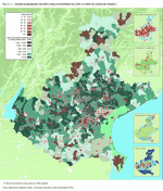
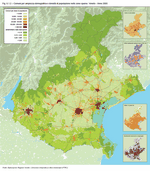
The lower average age of the foreign population compared to those born locally acts to counteract population ageing in the Veneto: 24% of all foreigners resident in the Veneto are minors, the highest percentage of all Italy. Nonetheless the Veneto is among Italy's oldest regions. At the end of 2005 there were 138 persons aged 65 and older for every 100 young people under 15 years of age. Only in the past two years has the national figure showed an even more pronounced population disequilibrium than the Veneto, and very clearly so in the last year when Italy counted 140 elderly per 100 youth (Figure 6.1.1) and (Figure 6.1.2).
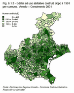
The median population density in the Veneto is 258 people per km2. The lowest is found in the mountain area of the Belluno province (58 per km2), while the figures for the central area are much higher and amount to 416 inhabitants per km2 in the province of Padova (Table 6.1.1). Hand in hand with demographic expansion goes an increased housing demand, also brought about by higher labour mobility and new family structures: more but smaller families, more single people and lone elderly, and more fragmentation due to separation and divorce. According to the 2001 census, which provides us with the latest available data, residential buildings erected after 1991 account for 9% of the total. Of these, roughly 60% are equally distributed among the provinces of Padova, Treviso and Vicenza. Furthermore, the more recent settlements north of the central area, along the submontane axis, have lead to the consolidation of a land-use system characterised by alternating high and low-density areas.
Over 60% of all new buildings comprise two floors, as do most of the older structures. This is in general a rather family-friendly make-up, but also leads to an extensive horizontal use of territory in all provinces. Higher rise buildings account for a small share of 4% only (Figure 6.1.3) and (Table 6.1.2).
The cities
The majority of the Veneto's population (three million people out of a total of less than five million) is concentrated in the cities and in the first and second suburban belts. These areas are now marked by an ever increasing exchange of people and goods, a situation that is profoundly different from the agriculture-based settlement structure which was dominant up to the early 1970s.
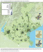
In 1971, the cities had 75% more inhabitants than the first suburban belts and 42% more than the second belts. In 2005, by contrast, the provincial capitals, the municipalities of the first belt and those of the second belt all counted roughly the same number of inhabitants. This fact conveys the real meaning of terms such as "urban sprawl" or "urbanisation of the countryside". In fact, the cities of the Veneto have extended into the surrounding territories, and with them most urban functions. So today, the population of the first and second suburban belts is similar to that of the cities as regards number and socio-economic profile. The primary services are no longer concentrated in the provincial capitals only. Instead, they are more or less evenly spread over the areas outside the cities, responding to the requirements of the population. Examples include the extensive distribution of institutions of higher education and more recently also the decentralised settling of university outposts or the spatial organisation of health care services. Nevertheless, the cities maintain a higher service density, for instance as regards the large hospital centres and the services of the judiciary, but also as regards the main share of cultural attractions (Figure 6.1.4).
The above-discussed dynamics give evidence of how the central portion of the Veneto has become an integrated whole of settlement and production. Within this system, however, nerve centres stand out where the internal links are more intensely bundled. First and foremost, there is the urbanised area between Padova and Venezia which is basically uninterrupted and characterised by strong internal mobility. Secondly, there is the urbanised area which has developed out of the centres of Vicenza and Treviso and encompasses also the municipalities north of these two provincial capitals. In both historical and geographical terms, an urban spread has been created in terms of residential areas, services and production. Lastly, there is the city of Verona, which continues to expand towards its neighbouring municipalities and forms an urban-rural belt along an axis that extends west towards Lombardia and east towards Vicenza.
|
| Figure 6.1.1 |
 |
| Figure 6.1.2 |
 |
| Table 6.1.1 |
 |
| Figure 6.1.3 |
 |
| Table 6.1.2 |
 |
| Figure 6.1.4 |
 |
|


 Index
Index 


